Maps for a data-driven Europe
Providing an insight into potential of solar energy

How a ‘Geo-common’ strategy supports major Lidar and land use projects in France.
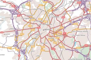 The European External Action Service (EEAS) is the European Union’s (EU) diplomatic service, and since 2011 has carried out the EU’s Common Foreign and Security Policy to promote peace, prosperity, security, and the interests of Europeans across the globe. It uses EuroRegionalMap, a pan-European dataset available through the Open Maps For Europe project, for planning military mobility and investment programmes.
“We need a coherent database, and we need data that we can trust and rely on. We need authoritative geospatial information, quality controlled, preferably from governmental sources with borders and boundaries that should reflect the EU view. We also need a common place where we can do planning. So, the 1:250 000 scale seamless open data is crucial for us in determining, for example, where we reinforce our bridges so that heavy trucks can cross them without breaking or planning our routing systems.”
Lieutenant-Colonel Soenke Fischhoefer, Senior Geospatial Officer EUMS, EU External Action Service.
The Geospatial Information Section of the United Nations uses Open Maps For Europe to provides a consistent representation of the world based on common geographies. Its vision is the universal use of geospatial information to underpin and support all roles, mandates and operations of the United Nations for a better world.
“Open data created using official information from Europe’s National Mapping, Cadastral and Land Registration Authorities provides common and consistent geographies to support the United Nations System. We know that we can rely on these Open Maps For Europe and, that in turn, our colleagues can trust the information we provide to them to support decision-making and data action.”
Kyoung-Soo Eom, Chief, UN Geospatial Information Section
The European Environment Agency (EEA) is using multi-themed topographic open data from official sources as a selectable background map in its European Ground Motion Service (EGMS). Provided through the Open Maps For Europe interface, EuroRegionalMap provides an option for users of the EGMS data viewer who prefer to use maps rather than satellite images.
“The use of EuroRegionalMap open data in the European Ground Motion Service data viewer not only demonstrates the value of information available from National Mapping, Cadastral and Land Registration Authorities, but also highlights the benefits of our cooperation. We fully support the ambition to include map data from all Copernicus Participating States in future releases of Open Maps For Europe.”
Henrik Steen Andersen, Contract Manager, Copernicus In Situ Data
"The main state topographic map scale 1:50 000 and access to it on NSDI pilot project geoportal will provide a single digital topographic base in Ukraine and in the future will allow to use it as a source of output data at the national, regional, and local levels. We are also convinced in the crucial role of local governments and central executive bodies in ensuring the development of geospatial data in Ukraine. The StateGeoCadastre is making every effort to accelerate this irreversible process”.
Sergii Zavadskyi, Acting Chairman, State Service of Ukraine for Geodesy, Cartography and Cadastre
Users of geospatial information in Ukraine are benefitting from updated 1:50 000 scale digital topographic maps and a new national database for topographic data.
Delivered as part of the ‘Maps for Good Land Governance’ project in cooperation with the Norwegian Mapping Authority, the main state topographic map was developed in close cooperation between the StateGeoСadastre, the State Enterprise ‘Research Institute of Geodesy and Cartography’, the State Enterprise ‘Ukrainian State Aerogeodesic Enterpris’, the Central Department of Military Topography and Navigation of the Armed Forces of Ukraine with the participation of other private enterprises.
The Quality Control Commission was established for adopting map sheets, with 1,288 nomenclature sheets for an area of 436,135 km2 accepted. To ensure automated quality control of the updated digital maps, a ‘validate’ tool, comprising a software package and geoportal of the project monitoring and support system, were created.
Benefits
“This programme will promote the value associated with accurate and relevant spatial data. The rapid delivery of a scalable and replicable national digital base map is not only relevant to cities such as Lusaka, but also has far reaching benefits at national and regional scale. The data OS has created will provide the evidence and information to support critical decisions when upgrading existing informal settlements and planning future infrastructure to promote economic prosperity.”
Andy Wilson Africa Region Director, Ordnance Survey, Great Britain
Ordnance Survey (OS) worked with the International Growth Centre (IGC) and the Commonwealth Association of Architects (CAA) to create an automated basemap of informal settlements in Lusaka, Zambia, in response to the challenges associated with urban growth, the availability of accurate and up-to-date data for creating well-planned and managed cities, and improving infrastructure at low cost.
Using aerial imagery provided by the Zambia Survey Department in the Ministry of Lands and Natural Resources and artificial intelligence (AI), OS used its advanced automated process to generate a new base map across 420km2 of Lusaka.
Using Machine Learning techniques, computers were taught what to look for, to label data and trace features such as buildings, roads and water in images using training data; this algorithm classified the various features and the technology then automatically created mapping quickly and accurately.
This innovative technique, using AI, is a rapid, accurate and cost-effective way to generate a detailed digital map that has a multitude of use cases, including the design and management of critical infrastructure services, land use and transport planning, land tenure, ownership and administration, and integration of future census data.
Benefits
“Our data is at the basis of sustainable goals in society. Only by working together and combining available high-quality data, can we achieve a solid base of the full picture for solar energy potential.’’
Frank Tierolff, Chair Executive Board Cadastre, Land Registry and Mapping Agency, The Netherlands
The Netherlands Cadastre, Land Registry and Mapping Agency (Kadaster) has created a database of information related to solar potential and solar photovoltaic (PV) installations, which is very useful for policymakers to reach targets related to the Climate Agreement. The data is used gain an insight into the potential for solar energy.
Kadaster has developed a method to assess this potential using two approaches. The first combines a 3D model based on aerial photography with objects from the Key Register Addresses and Buildings. The second approach uses object detection, which is a deep learning technique used to manage the Key Register Topography. This technique automatically detects changes in the landscape, such as the appearance of solar panels on roofs.
A 3D model, based on high resolution elevation data, was used to calculate solar radiation multiple times per day and several days per year. Deep learning techniques were employed to detect existing solar panels from very high- resolution aerial images for the whole of the Netherlands. The results of both techniques provide data for all individual buildings which is combined with information about function and ownership.
This is a good example of GeoAI, where the best of both worlds are combined to use large geographic datasets and create useful policy- and monitoring information for the energy transition.
Benefits
"It is our task to provide tools so that our data is accessible to the public as simply and free of charge as possible. We do this with the swisstopo app in a contemporary, user-friendly and convincing way."
Dr. Fridolin Wicki, Director, Federal Department of Defence, Civil Protection and Sport, Federal Office of Topography swisstopo
Swiss National Maps and other federal geodata can now be easily accessed free-of-charge via mobile devices thanks to the award-winning swisstopo app.
The app, which has already recorded over one million downloads, increases awareness and useability of swisstopo data by providing quality, reliable geographical information free of charge and without the need to provide login information.
Since the go-live in summer 2020, many new contents and functions have been added and the app has already recorded over one million downloads and was named ‘Master of Swiss Apps 2021’. Besides all National Maps, aerial photographs, aeronautical maps and historical maps,
the app also shows additional information relating to public transport, hiking, cycling, snow sports and aviation and includes planning, guidance or tracking functions, a panorama mode (virtual and augmented reality), search and positioning.
Developed with the external partner Ubique Innovation AG, it provides a future-proof tool for a high level of mobile usability of swisstopo's National Maps and geodata. With the corresponding Open Source Software Development Kit ‘Open Swiss Maps’, which was launched with the introduction of Open Government Data, it is also possible for third parties to easily integrate swisstopo data and basic functions in their own app.
Benefits
“Sweden has now implemented a scalable national infrastructure for exchange of standardised data where digital detailed development plans and 3D buildings are the first datasets.”
Susanne Ås Sivborg, Director General, Swedish Mapping,Cadastral and Land Registration Authority (Lantmäteriet)
Digital detailed development plans and 3D buildings are the first datasets to be created from Sweden’s scalable national infrastructure.
To enable everyone to consume the datasets via machine interface, national specifications have been set and implemented through extensive collaboration between Lantmäteriet, municipalities, other authorities and system vendors.
The entire infrastructure is built on four legal roles: producer, consumer, coordinator, and data hosting.
The infrastructure is also in line with the planned and existing building blocks and ground data framework that is held by the Swedish authority for digitisation.
Agile working has enabled Lantmäteriet to develop several test versions of both specifications and technical solutions. It has also set up an agreement model for producers and consumers. Consumers need only sign the one agreement to get access to data from multiple producers such as municipalities and authorities.
Benefits