
The award-winning Open Maps For Europe project was co-financed by the Connecting Europe Facility of the European Union, It was coordinated by EuroGeographics in partnership with the National Geographic Institute (NGI) Belgium and ran until 31 December 2022.
By the close of the project, more than 4,000 registered users had downloaded around 4,700 datasets and carried out 6 million web service transactions via the Open Maps For Europe interface. The most popular dataset was EuroGlobalMap, multi-themed topographic open data at 1:1 million scale, followed by 1:250 000 scale EuroRegionalMap and EuroDEM, a 1:100 000 scale digital open data elevation model providing height data. The datasets are also discoverable on the European Data Portal and on the NGI Belgium data portal.
This was the first time that these datasets, created using EuroGeographics members authoritative geospatial information and EuroGeographics’ unique data integration process, have been easily discoverable, accessible, and released as open data under a single licence. Thiscustomised approach harmonises official national geospatial information to standard specifications so users can be confident that it is consistent, comparable and easily shared.
December 2022
Call for sustained funding to invest in pan-European maps for a data-driven Europe
National providers of geospatial information are calling for sustained funding for pan-European mapping to ensure that the power of official location data can be unlocked for the benefit of all.
The importance of investment in trusted and reliable geospatial data to realise the EU’s decade of action was demonstrated by members of EuroGeographics during a special debate for MEPs and policy-makers at the European Parliament.
Opening the discussion, Cristian Bușoi, Chair of the European Parliament’s Committee on Industry, Research and Energy (ITRE), said: “Data is an essential resource for economic growth, competitiveness, innovation, job creation and societal progress in general. The entire European Strategy for Data and legislative packages, scrutinised by the ITRE Committee that I am chairing, focuses ultimately on putting people first in developing technology, and defending and promoting European values and rights in the digital world.”
“All data producers, and especially public data providers, must ensure that their data is ready to underpin this decade of action. They have an immense responsibility to ensure that their data meets citizens’ needs and supports national and European bodies to address the challenges they are facing.”
“It is not enough to possess the data It must be widely accessible, reusable, trustworthy and secure. This is what EuroGeographics is doing with its latest project – Open Maps For Europe which I am sure will be very successful.”
November 2022
Open Maps For Europe adds data from four more countries for final release
Open Maps For Europe has today announced that official geospatial data from four additional countries is included in the project’s third and final release.
North Macedonia and Switzerland have contributed multi-themed topographic open data for 1:250 000 scale EuroRegionalMap, with Denmark and Slovenia adding their data to the Cadastral Index Map prototype. North Macedonia has also provided authoritative geographical names for the multilingual Open Gazetteer.
November 2022
Open Maps For Europe wins BeGeo Best Project Award
Open Maps For Europe has been awarded the GeoSpatial 2022 Professional Best Project Award at the BeGEO congress in Brussels.
The seventh BeGeo Congress, organised by The National Geographic Institute Belgium and Agoria, with the support of TMAB Business Events, pulled together geo-information experts from government, academia and the private sector in the Benelux area.
November 2022
Case Study: Delivering data to promote peace, prosperity and security
The European External Action Service (EEAS) is the European Union’s (EU) diplomatic service, and since 2011 has carried out the EU’s Common Foreign and Security Policy to promote peace, prosperity, security, and the interests of Europeans across the globe. It uses EuroRegionalMap, a pan-European dataset available through the Open Maps For Europe project, for planning military mobility and investment programmes.
“We need a coherent database, and we need data that we can trust and rely on. We need authoritative geospatial information, quality controlled, preferably from governmental sources with borders and boundaries that should reflect the EU view. We also need a common place where we can do planning. So, the 1:250 000 scale seamless open data is crucial for us in determining, for example, where we reinforce our bridges so that heavy trucks can cross them without breaking or planning our routing systems.”
Lieutenant-Colonel Soenke Fischhoefer, Senior Geospatial Officer EUMS, EU External Action Service.
October 2022
Case Study: Providing common and consistent geographies to support the United Nations System
The Geospatial Information Section of the United Nations, also Co-Secretariat of the Committee of Experts on Global Geospatial Information Management (UN-GGIM) provides data, analysis and visualisation for decision-making and data action. Its vision is the universal use of geospatial information to underpin and support all roles, mandates and operations of the United Nations for a better world.
“Open data created using official information from Europe’s National Mapping, Cadastral and Land Registration Authorities provides common and consistent geographies to support the United Nations System. We know that we can rely on these Open Maps For Europe and, that in turn, our colleagues can trust the information we provide to them to support decision-making and data action.”
Kyoung-Soo Eom, Chief, UN Geospatial Information Section
September 2022
Case Study: Providing a web map service for investigating European Ground Motion
The European Environment Agency (EEA) is using multi-themed topographic open data from official sources as a selectable background map in its European Ground Motion Service (EGMS). Provided through the Open Maps For Europe interface, EuroRegionalMap provides an option for users of the EGMS data viewer who prefer to use maps rather than satellite images.
“The use of EuroRegionalMap open data in the European Ground Motion Service data viewer not only demonstrates the value of information available from National Mapping, Cadastral and Land Registration Authorities, but also highlights the benefits of our cooperation. We fully support the ambition to include map data from all Copernicus Participating States in future releases of Open Maps For Europe.”
Henrik Steen Andersen, Contract Manager, Copernicus In Situ Data
June 2022
Case Study: Using the power of touch to bring tactile maps to life
The Netherlands Cadastre, Land Registry and Mapping Agency (Kadaster) is committed to making its information easily accessible to everyone. To enable blind and visually impaired people to benefit from its data, it is developing a series of tactile maps for navigating by touch.
“Our aim is to make all geodata from Kadaster available and accessible to everyone. For blind and visually impaired people, the best way is to create tactile maps. Open Maps For Europe provided an easy way to access official topographic data from different countries and apply the production process we have developed for The Netherlands to other parts of Europe.”
Daan Rijnberk, Kadaster
May 2022
Open Cadastral Map prototype and data updates
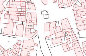
The Open Cadastral Map prototype provides large-scale coverage for four countries.
The data is now available via the Open Maps interface and this first iteration includes Poland, The Netherlands, Czech Republic and Spain. The map takes INSPIRE open data and allows the user to find out what is available from national sources in one place before obtaining the data from the official provider. The cadastral map comprises four data types: Administrative Units, Cadastral Parcels (and Cadastral Zones), Buildings (and Building Parts) and Addresses.
The second release of Open Maps for Europe includes updated versions of EuroGlobalMap (EGM 2022) and EuroDem, a pan-Europe open data elevation model providing height data.
September 2021
First Open Maps For Europe datasets released
Users can now access the first free-to-use maps via the Open Maps For Europe online gateway.
Four open datasets created using official national map, geospatial and land information from members of EuroGeographics are included in this first release:
- EuroRegionalMap – multi-themed topographic open data at 1:250 000 scale – initial data provided by 31 National Mapping, Cadastral and Land Registration Authorities.
- EuroGlobalMap – provides multi-themed topographic open data at 1:1 million scale covering 55 countries and territories in the European region.
- EuroDEM – 1:100 000 scale digital open data elevation model providing height data provided by 26 National Mapping, Cadastral and Land Registration Authorities.
- Open Gazetteer – an open gazetteer service providing authoritative multilingual geographical names – data provided by 36 National Mapping, Cadastral and Land Registration Authorities.
Release 1 also includes Pan-European Imagery provided by Germany’s Federal Agency for Cartography and Geodesy –10 metre resolution high-quality open data images and mosaics as uniform reference products for mapping and visualisation, created from data taken from the European Union´s Earth observation programme Copernicus (Sentinel-2, L1C-L2A).
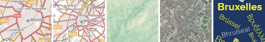
The project is coordinated by EuroGeographics,, in partnership with the National Geographic Institute (NGI) Belgium. The cartography and styling on the Open Maps For Europe interface is based on NGI Belgium cartography.
Sign up to our newsletter for updates.