
Open Maps For Europe 2 (OME2) is developing a new production process and technical specification for free-to-use, edge-matched data under a single open licence. Authoritative 1:10 000 scale data for 10 countries will be delivered via the user interface built by the award-winning Open Maps For Europe Project.
OME2 is also enhancing the five existing Open Maps For Europe datasets including the Open Cadastral Map; EuroGlobalMap; and EuroRegionalMap.
Find out how the OME2 harmonised high-value large-scale data prototype and enhanced datasets are delivering value to users in the public and private sectors as well as academia.
Case Study:
Supporting cross-border analyses of healthcare and education services
 Eurostat, which provides official statistics to the European Union, used the transportation theme of the Open Maps for Europe 2 (OME2) high-value, large-scale, pan-European prototype to produce its new dataset on the localisation of health and education provision.
The quality of geographical data has an impact on the result of spatial analysis; therefore, we need up-to-date, multi-scale, comparable, edge-matched geospatial data covering the European territories. The Open Maps for Europe 2 (OME2) high-value, large-scale, pan-European prototype is an excellent contribution to meet these requirements. Our objective is to show how vector topographic datasets from National Mapping, Cadastral and Land Registration Authorities and GIS methodologies can be used to produce statistical indicators for policymakers.”
Julien Gaffuri, GIS and Cartography Engineer, Eurostat
Case Study:
Providing a geological base map for the new Digital Structural Model of Italy
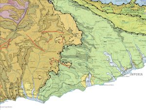 The University of Siena uses EuroRegionalMap, multi-themed topographic open data, as a base map for the geological cartography the new Digital Structural Model of Italy (DiSMI). As a result, the 1:250,000 scale vector geological map will cover not just Italy but also the whole of the Alps as well as the neighbouring areas of France, Switzerland, Austria, Slovenia and Croatia.
The Digital Structural Model of Italy (DiSMI) we are developing also covers the Alps and adjacent areas, we therefore need a topographic base map, ideally based on vector data, that is continuous across national borders. The free pan-European datasets that have been enhanced by the Open Maps For Europe 2 (OME2) Project provide the coverage we require at the resolution we want.”
Paolo Conti, Associate Professor of Structural Geology, University of Siena, Italy
Case Study:
Enabling spatial analysis to understand housing demand and supply
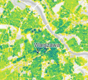 To determine building density and enable spatial analysis of the status of Europe’s residential space, Eurostat, which provides official statistics to the European Union, uses the Open Cadastral Map to gain an overview of the information available. It then follows the link to the national geoportal to download the vector data, which includes the geometry and attribute of each single building.
To deliver the statistics required to support European policies, we need reliable geographical information – including building data – for the European territories. By compiling and harmonising NMCA data on buildings, the Open Maps for Europe 2 (OME2) Open Cadastral Map provides us with an overview of the information available from official national sources.”
Julien Gaffuri, GIS and Cartography Engineer, Eurostat
Case Study:
OME2 Project and Nazka Mapps bring boundaries into the open to show benefits of harmonised data
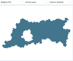 Belgium-based Nazka Mapps is using EuroRegionalMap and EuroGlobalMap acecessed via Open Maps For Europe in its open solution boundaries-api.io.
Without the OME2 project, it would not have been possible to create our Boundaries-API, which is designed for application builders that do not want to worry about collecting, harmonising, storing and updating data on administrative boundaries. If this data was not available, we would have to revert to petitioning each country individually, or make use of global datasets that can be unreliable for local situations.”
With Open Maps For Europe we gather information from the source – the national geographical agencies – so we know that we can trust this data. And, as Open Maps For Europe datasets are open, we then decided to make our solution open to give other map application builders access to accurate and up-to-date boundary information without the hassle of data collection and maintenance.”
Ann Crabbé, Product Owner, boundaries-api.io, Nazka Mapps
Testimonials
The OME2 project is co-funded by the European Union. It is being delivered by a consortium comprising: EuroGeographics, the not-for-profit membership association for Europe’s National Mapping, Cadastral and Land Registration Authorities; National Geographic Institute, Belgium; National Institute of Geographic and Forest Information, France; Hellenic Cadastre; General Directorate for the Cadastre, Spain; and Cadastre, Land Registry and Mapping Agency, The Netherlands.
Views and opinions expressed are however those of the author only and do not necessarily reflect those of the European Union or European Commission. Neither the European Union nor the European Commission can be held responsible for them.
![]()