
Open Maps For Europe 2 Project releases first prototype for harmonised high-value data
The Open Maps For Europe 2 (OME2) project has today (28 May 2024) announced the first release of a prototype for harmonised large-scale, high-value data.
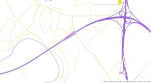
OME2 Prototype Maastricht border.
Available via www.mapsforeurope.org, version one provides 1: 10 000 scale authoritative administrative boundary and transport data for Belgium, France and The Netherlands. It is the first dataset created using the new production process, developed by several OME2 Consortium members led by National Institute of Geographic and Forest Information (IGN France), to deliver edge-matched official geospatial information from multiple national sources. The image right shows the Maastricht border.
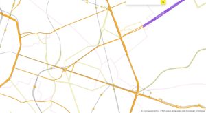
In addition to IGN France, the project partners comprise: EuroGeographics, the not-for-profit association for Europe’s National Mapping, Cadastral and Land Registration Authorities; National Geographic Institute, Belgium; Hellenic Cadastre; General Directorate for the Cadastre, Spain; and Cadastre, Land Registry and Mapping Agency, The Netherlands. Images below show: La Defense, Paris; Brussels; and Amsterdam.

OME2 Prototype La Defense, Paris.
“This is a really exciting milestone that will benefit national providers of geospatial data and users alike,” said Victoria Persson, Project Manager – Data Access and Integration, EuroGeographics.
“The prototype is aligned to key EU policies, as well as UN core geospatial data recommendations for local level actions, and provides large-scale administrative boundary information as well as transport and railway networks, ports and airports.”
“The authoritative data is harmonised across countries and available via the Open Maps For Europe interface. This saves users time, effort and resources as they will no longer need to visit individual Member State geoportals to access specific datasets, spend significant resources connecting them, or agree to multiple licences.”
OME2 Prototype Brussels.
She continued: “Our members are recognised as important enablers of cross-border data applications and services. By automating the production process, OME2 now transforms their national data to meet the specifications for high-value pan-European datasets. Members simply complete a conversion table which typically takes just a few days, significantly reducing the time and resources required. Additional work is then only needed in the rare event that the data structure changes. The process also responds to user needs by enabling annual updates.”
“Our members can re-use these techniques nationally and exchange good practices to advance the data sharing tools needed to deliver free-flowing, interoperable data for the single market. In doing so, OME2 demonstrates how demand for geospatial information in all common data spaces of the European Strategy for Data can be met.”
By the end of 2025, the OME2 prototype is expected to cover 10 countries with three key themes identified by users and defined as high value by the European Commission – administrative boundaries, transport and hydrography. The project, which is co-funded by the European Union, is also enhancing the five existing Open Maps For Europe datasets, including the pilot Open Cadastral Map.

OME2 Prototype Amsterdam.
EuroGeographics is an international not-for-profit organisation (AISBL/ IVZW under Belgian Law. BCE registration: 833 607 112) and the membership association for the European National Mapping, Cadastral and Land Registry Authorities.
The OME2 project is co-funded by the European Union. It is being delivered by a consortium comprising: EuroGeographics, the not-for-profit membership association for Europe’s National Mapping, Cadastral and Land Registration Authorities; National Geographic Institute, Belgium; National Institute of Geographic and Forest Information, France; Hellenic Cadastre; General Directorate for the Cadastre, Spain; and Cadastre, Land Registry and Mapping Agency, The Netherlands.
Views and opinions expressed are however those of the author only and do not necessarily reflect those of the European Union or European Commission. Neither the European Union nor the European Commission can be held responsible for them.
![]()