EuroGeographics highlights key role of European NMCAs at GGIM8
News | 23 Aug 2018
 European NMCAs have an important role to play in UN-GGIM and, as their membership association, EuroGeographics is committed to ensuring their distinctive voice and interests are heard.
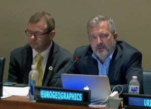
Earlier this month, we were pleased to participate in GGIM8 in New York where we provided a collective voice for members.
Secretary General and Executive Director, Mick Cory made a series of interventions highlighting members’ contributions, particularly in the work of UN-GGIM: Europe. He also reiterated EuroGeographics support for initiatives to strengthen geospatial information management, the Global geodetic reference frame, and the implementation and adoption of standards, reminding delegates of the expertise within the Knowledge Exchange Networks (KENS).
Strengthening geospatial information management
EuroGeographics:
- Noted the contribution of the Global Spatial Data Infrastructure (GSDI) Association, and its generous donation to capacity development initiatives. This is something that EuroGeographics, as a member of the Board GSDI, encouraged and strongly supported. We are pleased to note it has already had an impact.
- Drew attention to the ongoing contribution made by members to the work of UN GGIM Europe. Not only do some of our members play an active role, but our members also provide funding, through EuroGeographics, for the UN-GGIM: Europe Secretariat and we are pleased to continue to provide other support in establishing this important global endeavour by making a number of interventions.
- Welcomed and supported the proposal to host the 6th High-level forum in Europe, and thanked the United Kingdom of Great Britain and Northern Ireland for taking the lead in this work. He also welcomed the United Kingdom’s leadership in the revision of the Future Trends document and offered support and assistance, through all 5 stages of the development plan, including the use of our network members, the National Mapping, Cadastral and Land Registries of geographic Europe.
Global geodetic reference frame
EuroGeographics:
- Noted and read with interest the present report and the work of the Subcommittee on Geodesy.
- Supports and welcomes the aspiration for a strengthened global governance structure whilst stressing a number of critical points for the sub-Committee to consider, in particular the importance of demonstrating that this will indeed reflect in better governance, better decision making, better communication and further out-reach.
- Requested that more is done to ensure that those who are not already active or expert in geodesy get involved and better understand the importance of this work, and also better understand the work of the many different bodies involved in geodesy internationally, and explain their relevance and importance in these challenging times.
- Commended the ambition to strengthen governance and highlighted that this requirement also extends to a number of other areas of geospatial information management, particularly in support of the Sustainable Development Goals (SDGs), and should be considered further by the UNGGIM Secretariat.
- Supported engagement with our members to ensure they are fully informed and aware of the proposals before formal positions are requested. To avoid duplication of effort, our Positioning Knowledge Exchange Network in Europe should be used to inform them of these important developments.
Determination of 14 global fundamental geospatial data themes
EuroGeographics:
- Acknowledges and welcomes the report and the activities of the working group in preparing the definition of the 14 global fundamental data themes.
- Noted that administrative boundaries are one of the fundamental themes and highlighted that EuroGeographics continues to contribute to the Second Administrative Level Boundaries (SALB) programme, through the provision of its pan-European open dataset compiled from 39 national authoritative datasets from our members.
- Spoke of the work and contribution of all our members to this dataset, and in particular to the standardisation efforts undertaken by IGN France in preparing the data in SALB-ready format.
- Encouraged other member states and organisations to help support this project, and stressed that EuroGeographics remains ready to assist and advise, on the processes, procedures and organisation, and our experience if requested to do so.
- Highlighted that it shares the view that communication and promotion of these global fundamental data themes is essential, and noted in particular the value and importance of endorsement by the UN Committee of Experts.
- Suggested the use of simple, straightforward and non-technical language suitable not only to our own community, but also to those throughout government, in particular to those responsible for the national mapping, cadastral and land registries. This will help strengthen the relevance and importance of their work, and how it contributes to the global geospatial information management initiative and SDGs.
Implementation and adoption of standards for the global geospatial information community
EuroGeographics:
- Noted and acknowledged the report and activities carried out by the Open Geospatial Consortium, technical committee 211 of the International Organization for Standardization, and the International Hydrographic Organization.
- Drew attention to the work of the Quality Knowledge Exchange Network which is about to publish updated guidelines for implementing the ISO19100 Geographic Information Standards in European National mapping, cadastral and land registries. We also expressed the wish to contribute this document to the UNGGIM knowledge database as a good practice example elaborated by the experts from Europe’s National Mapping Authorities.
Call to action
Read our latest news